Hotline: +84 866 227 878
- SG$ Singapore Dollar
- A$ Australian Dollar
- £ British Pound Sterling
- C$ Canadian Dollar
- € Euro
- MYR Ringgit Malaysia
- US$ United States Dollar
- đ Vietnamese Dong


 Hotline/Whatsapp: +84 86 622 7878
 Email: sales@asiamystika.com
 About Us
 Destinations
 Travel Styles
 Travel Guide
 Blogs
Blogs
 News
News

Cambodia's climate, like that of the rest of Southeast Asia, is dominated by monsoons, which are known as tropical wet and dry because of the distinctly marked seasonal differences.
Cambodia has a temperature range from 21 to 35 °C (70 to 95 °F) and experiences tropical monsoons. Southwest monsoons blow inland bringing moisture-laden winds from the Gulf of Thailand and Indian Ocean from May to October. The northeast monsoon ushers in the dry season, which lasts from November to April. The country experiences the heaviest precipitation from September to October with the driest period occurring from January to February.
Cambodia has two distinct seasons. The rainy season, which runs from May to October, can see temperatures drop to 22 °C (72 °F) and is generally accompanied with high humidity. The dry season lasts from November to April when temperatures can rise up to 40 °C (104 °F) around April. Disastrous flooding occurred in 2001 and again in 2002, with some degree of flooding almost every year. Severe flooding also affected 17 provinces in Cambodia during the 2020 Pacific typhoon season.
The climate in the Northwestern region of Cambodia is tropical, hot and humid, with two distinct seasons: a rainy season from May to October and a dry season from November to April. The rainy season is influenced by the southwest monsoon, which brings heavy rains and high humidity, especially in the latter part of the season. The dry season is characterized by lighter and drier winds of the northeast monsoon, which bring variable cloudiness and infrequent precipitation.
This is the area most popular for tourists visiting the country. The reason for this is that the Northwest is home to Angkor Wat and the surrounding archaeological park. Siem Reap, the largest city in the region, is the gateway for most visitors to Angkor.
The lands are very fertile thanks to the neighboring Tonlé Sap lake. This means that, outside of the city, you will see plenty of rice fields being worked on. However, the region is also amongst the poorest in the country. Thankfully, with the developing infrastructure, this may change soon. This will allow more visitors to see and experience the traditional Cambodian lifestyle.
The Northwestern region of Cambodia is home to diverse ecosystems, such as savanna grasslands, deciduous forests, evergreen forests, and mangroves. It also hosts a variety of wildlife species, such as elephants, wild oxen, deer, tigers, leopards, bears, and many birds and reptiles.
The Eastern region of Cambodia is part of the central lowland region, which has a tropical climate with high temperatures and two distinct seasons: a rainy season from May to mid-November and a dry season from mid-November to April. The rainy season is influenced by the south-west monsoon, which brings heavy rains and high humidity, accounting for 80-90% of the annual precipitation. The dry season is characterized by lighter and drier winds of the northeast monsoon, which bring variable cloudiness, infrequent precipitation, and lower humidity.
Wildlife, nature and traditional lifestyles are the main draws for this region. You can take pleasant walks or bike rides around the smaller cities. There are guided tours available for those who want to know more about the history of the area. Traveling between the smaller villages can also be an interesting experience. The lifestyle here is generally slow when compared to the bigger cities elsewhere in Cambodia.
Food is generally more traditional, with street food vendors offering cheaper alternatives to restaurants. For drinks, you can try one of the ‘TV bars’, where locals hang out and watch films with a drink or two.
The Cardamom and Elephant Mountains are two mountain ranges in southwest Cambodia and southeast Thailand that form part of the Indo-Burma biodiversity hotspot. The climate of these mountains is influenced by the monsoon winds that bring heavy rainfall to the western slopes facing the Gulf of Thailand, and create a rain shadow effect on the eastern slopes facing the interior Cambodian plain. The temperature varies depending on the elevation and season, but generally ranges from 15°C to 35°C. The highest peak in these mountains is Phnom Aural, which reaches 1,813 m above sea level.
This region is also underdeveloped due to the poor infrastructure, the mountains, and the lingering presence of landmines. However, the coastal areas are a tourist hotspot, but not overly spoilt. Sihanoukville is home to one of the most popular beaches in the country, making it one of the main attractions in the region.
Cambodia’s second-largest city, Battambang is located in this region. Despite being the second biggest, it is not a regular stop for visitors who prefer the more popular Phnom Penh, Siem Reap, and Sihanoukville. The city is home to beautiful temples, a circus, and statues. You should definitely stop by to explore.
Last but not least, the islands of Koh Rong and Koh Rong Sanloem. These two are amongst the biggest of the island chains of the region. You can expect beautiful beaches and varied landscapes as you move inland. These are understandably popular but still with a natural charm.
The Mekong Lowlands of Cambodia are part of the Lower Mekong River Basin, which has a tropical monsoonal climate. This means that the region experiences wet and dry seasons of approximately equal length, influenced by the Southwest Monsoon. The wet season lasts from June to November, bringing heavy rainfall and frequent flooding to most of the basin. The dry season lasts from December to May, with cooler temperatures and low rainfall, except for the Mekong Delta in Cambodia’s Kratie province and in Viet Nam. The average annual temperature in the Mekong Lowlands is around 28°C, with little seasonal variation.
The Mekong flows through the region, ultimately flowing around and back into Vietnam. Tonlé Sap, the country’s largest lake also occupies this low-lying area.
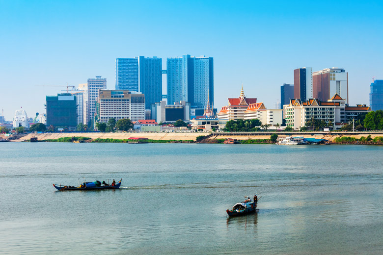
The capital, Phnom Penh (ភ្នំពេញ), is located here. The city was purposely built on the banks of the Mekong River to provide resources as well as enable travel. The temperature here remains warm year-round, with very little variations in day-to-day temperatures.
There are numerous other smaller cities around the region that still maintain some French-style architecture and a slower pace of life. These overlooked gems are not far from the capital, so you should take some time to stop by.